


GPS NMEA Tool

Description of GPS NMEA Tool
GPS NMEA is an application designed for Android devices that enables users to view and analyze NMEA data generated by built-in GPS receivers. This app is particularly useful for those who wish to monitor their geographical location and obtain detailed information about satellite signals. Users can download GPS NMEA to enhance their navigation experience with precise data.
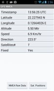
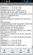
The app provides a summary view that displays essential data such as latitude, longitude, altitude, and speed. This feature allows users to quickly access critical geographical information, making it easier to understand their current location. In addition to the summary view, GPS NMEA also presents the raw NMEA data returned by the GPS. This data includes a series of sentences that contain navigational information, which can be beneficial for technical analysis or for individuals who require specific GPS data.
Another component of GPS NMEA is its capability to pause or save sample raw data for further analysis. Users can choose to save this data to external media, although it is important to note that accessibility may vary depending on whether the external media has been mounted on a computer. This functionality is particularly valuable for users who need to conduct in-depth assessments of their GPS data over time.
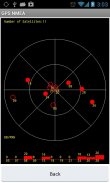
The app also features a satellite view, which displays the positions and signal strength of satellites that are currently in sight. This information can assist users in determining the reliability of their GPS signal, as well as enhancing their understanding of satellite positioning. By displaying this information, GPS NMEA helps users make informed decisions regarding their location tracking needs.
To utilize GPS NMEA effectively, users must enable location access on their devices. This step is crucial, as it allows the app to gather location data from the built-in GPS receiver. Once location access is granted, the app can provide accurate and real-time data, enhancing the overall user experience.
The user interface of GPS NMEA is designed to be straightforward, making it accessible for individuals with varying levels of technical expertise. Users can navigate between different views easily, allowing for a seamless experience when switching from summary data to raw NMEA data or satellite information. The app's layout ensures that users can focus on the information they need without unnecessary complications.
Moreover, GPS NMEA is particularly useful for outdoor enthusiasts, travelers, and professionals who rely on GPS technology for navigation. Whether for hiking, driving, or conducting research, the app provides valuable insights that enhance users’ understanding of their geographic environment. The ability to view raw data and satellite signals further enriches the user experience, making it a practical tool for various applications.
For those interested in analyzing GPS data, the capability to save and pause data samples is a noteworthy feature. This function allows users to collect and review data at their convenience, facilitating a more detailed examination of GPS performance. By having access to this information, users can identify patterns or issues that may arise during their travels.
In addition to these features, GPS NMEA is regularly updated to improve functionality and address user feedback. Should users encounter any issues or have suggestions for enhancements, the app provides a direct channel for communication with the developer. This commitment to user satisfaction ensures that the app remains relevant and effective for its audience.
The app is particularly beneficial for individuals who require detailed navigational data for research or professional purposes. By providing both summary and raw data, GPS NMEA serves as a versatile tool that caters to a wide range of user needs. Whether for casual use or more serious applications, individuals can rely on the app for accurate and timely GPS information.
As GPS technology continues to evolve, applications like GPS NMEA play a crucial role in enhancing user experience. The ability to access comprehensive data about location and satellite signals empowers users to make informed decisions about their navigation needs. Those who download GPS NMEA will find a reliable companion in their exploration of geographical data.
With its combination of summary data, raw NMEA data, satellite tracking, and data-saving capabilities, GPS NMEA stands out as a valuable resource for anyone interested in GPS technology. The user-friendly interface and commitment to functionality further solidify its place as a practical tool for navigation and data analysis.
By incorporating these features, GPS NMEA meets the diverse needs of its users and serves as an essential application for both casual and serious GPS users alike.
GPS NMEA Tool - Version 1.1
(05-07-2014)
GPS NMEA Tool - APK Information
APK Version: 1.1Package: com.ppillai.gpsnmeaLatest Version of GPS NMEA Tool


Apps in the same category

You may also like...


